Explore the Amargosa
Explore
Come explore the gorgeous lands of the Amargosa.
Where is the Amargosa?
The Amargosa National Wild and Scenic River lies between Las Vegas and Death Valley.
It begins in Nevada, north of the town of Beatty, and begins it’s journey by heading southward. It collects groundwater and spring water along its way, crossing the state line into California, and staying well hidden under the surface.
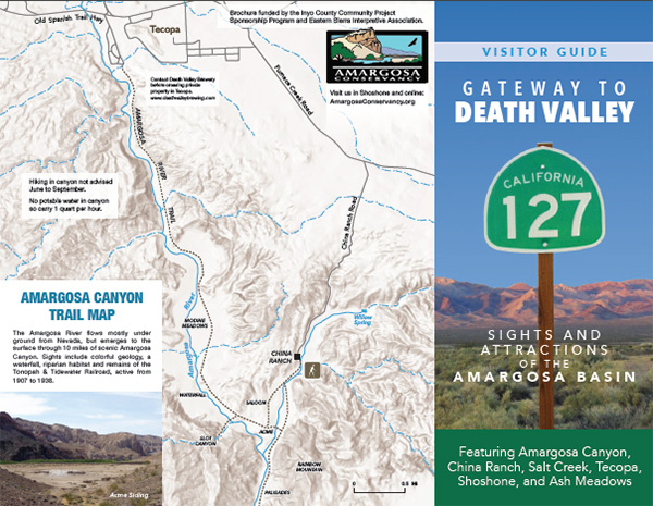
The river appears at surface level near the town of Shoshone, where it picks up additional flow from Shoshone Spring. Continuing south through the town of Tecopa, the river drops into the Amargosa Canyon – a lush and dramatic place of plants, birds, and sculptured mudstone walls.
Near the Dumont Dunes, the river bends westward then north and heads for Badwater Basin in Death Valley National Park. Here the river terminates in the lowest point in North America.
Explore the Amargosa

Birding in the Basin
The Amargosa basin draws birders from all over.

Native Plants & Wildlife
Learn about the unique ecosystem of the Amargosa.

DISCOVER: ASH MEADOWS NATIONAL WILDLIFE REFUGE
The largest oasis in the Mojave Desert, and home to more unique species than anywhere else in the United States.

History
Report on the 1903 Building
[PDF]